
Welp, here I am again talking about Ian. This time I’m talking about the coverage of Ian’s tropical storm winds. Let’s put up the maps.

The National Hurricane Center’s current track shows the extend of the winds. Nearly all of the Florida peninsula is covered, including south-east Georgia and the southern end of South Carolina. Let’s look at the Washington Post’s tracker map.
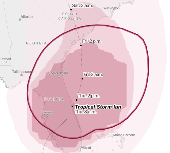
The Washington Post map is a more refined view of the NHC map. The red ring around the center of tropical storm Ian shows the extent, as of 8 am Thursday, of Ian’s tropical force winds. You can look at space photos of Ian all day long, but you really need these maps to show the effect of those storms. And this storm, even though it’s now “only” a tropical storm, never-the-less is effecting three southern states. Florida won’t see the last of Ian until mid-day Friday. This is one more example of what global warming/climate change has produced, far more severe hurricanes.
I was living in Orlando in 2004 when hurricane Charley came ashore at the same spot Ian did in 2004. Charley passed over Orlando and tore up the area to the point that we were without power for over a week, back when Florida Power serviced the region. That was the year my first daughter was starting as a freshman at Florida State University in Tallahassee. When we finally left in the family van to drive her up, power was still out. It came back on two hours after we left (our next door neighbor called us). Charley was about half the size of Ian. Ian caused less damage to us this time for a number of reasons:
- Our electricity provider, Florida Power, sold the service area we live in to Duke Energy. Duke has spent years and money strengthening the electrical infrastructure in their service area to the point where this time, unbelievably, we did not loose power as soon as the first bit of wind started to blow and rain started to fall. We still have the occasional outage due to idiots driving cars and smashing them into power poles, but they are thankfully infrequent and very short lived.
- Ian made a critical turn further east right before it made landfall.
- Ian was slower moving and dissipated considerably more energy as it moved through the Florida peninsula. By the time it got close enough to Orlando to cause issues it was far weaker than Charley had been. Regardless of how events turned out here, the tremendous damage to southwest Florida is far greater with Ian than it was with Charley. Tampa in 2004 only felt winds between 25 to 35 mph from Charley. Wind speeds were at least double that with Ian. And if the earlier forecast with Ian making landfall at Tampa had held true, then Tampa would have been effectively wiped off the map.
Extreme weather events like Ian are now are future.

You must be logged in to post a comment.