ian, #4

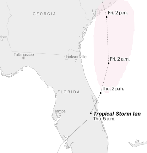
This will be the last post as far as the storm itself is concerned. We managed to survive the night. This is where and what Ian was at 5 am. I’m sure Ian is even closer to exiting Florida as I write this.

I’m using the Washington Post storm tracker as it provides the clearest forecast track of Ian.

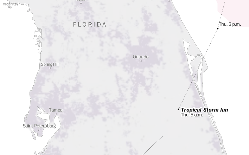
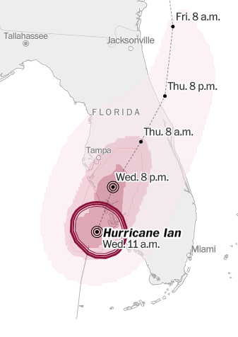
Ian is now “just” a tropical storm. Over the last 12 hours, Ian dropped from a near-category 5 hurricane to a sprawling tropical storm. There’s still lots of wind and rain and I received a flash flood alert from Orange County/Orlando until just about now. I can see lots of debris down, such as branches and leaves everywhere. But we’ve suffered nothing in comparison to Florida’s Gulf coast where Ian came ashore. To give an idea of how bad it is for Florida, here’s a current power outage map for Florida ( https://poweroutage.us/area/state/florida ).


The total number without power right now is sobering: 2.5 million. The worst hit are all the counties showing red on the map. Even Orange county is, well, orange. You can see broadly the swath Ian cut across the Florida peninsula. You can see Ian’s reach up to the northern counties with the green. Ian was a monster storm. It’s going to take a while to pick up from this one. And then we’re going to have to think good and hard about building right on both coasts.

ian, #3

Ian is getting ready to make landfall at Port Charlotte, Florida. I’ve read reports that at least 100,000 Floridians have already lost power before official landfall. A bit of research shows that there’s about 800,000 people in that general area, less than the three million that live in Tampa, where Ian was initially forecast to come ashore 48 hours ago. I’ve read reports that it’s a category four hurricane, then reports it’s a category five. What category it is is now a moot point. Ian is a big, fat, destructive storm that will linger over western central Florida for anywhere from 24 to 36 hours.

Here’s another view of the storm, courtesy of the Washington Post ( https://www.washingtonpost.com/weather/2022/09/24/ian-storm-tracker-map/ ). The storm track and map are a lot clearer. Both tracks show Ian’s strength dropping drastically between Wednesday 8 pm and Thursday morning 8 am.

Right now there’s a steady light rain. There is a steady, light wind, with some gusting. The rain isn’t continuous. For example, it stopped long enough this morning for me to get the dogs outside to do there business, more than once. All the animals are anxious, and are clustering around the humans in the house. It’s not unusual to sit in my chair and have at least two lap cats, sometimes three. The others just find a very close spot to me and sit.

It’s not like I’m unaware of the rest of the world. I’m still reading about the Ukraine war, the sabotage of Nordstream 1 and Nordstream 2 in the Baltic Sea, the cratering in value of the British Pound and all that that implies, the far right political swing (again) in Italy, as well as all the continuing political shenanigans and legal gyrations that T**** and his minions are performing.

It’s moments like these that I feel like I’m living in a real-world version of the movie “Don’t Look Up.”

Update 2 pm

The Orlando mayor has requested that all non-essential surface traffic and travel end by this time. Ian is now tracking somewhere over, or very near, Orange County, Florida, where I live. The rain has stopped for at least an hour, but the winds are slowly rising. Ian’s eye wall has come ashore at Fort Myers, Florida, south of Punta Gorda. Winds are 155 mph, category four.