

The path of Dorian through the Caribbean and on to Florida has been shifting further and further east. I woke up this morning to this forecast track, where Dorian is now projected to skirt Florida landfall and instead move up the coast and strike South Carolina around Charleston. Looking at the last two posts before this, the forecast map has had Dorian’s track moving eastward to today’s.
Do I feel safe? Is Florida out of the woods? No and no. Every forecast is made on an eight hour cadence. Every forecast has the hidden caveat that this is how the hurricane will travel if nothing changes from the point the forecast is made over the next five days. Everything is dynamic.
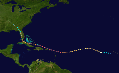
A classic example of unpredictability is Hurricane Irma from 2017. While the historical track doesn’t show it, during the latter stages before Irma finally hit Florida in the Keys, Irma had been forecast to miss Florida entirely and move into the Gulf. But Irma hit Florida and spent the next 48 hours basically chewing through the peninsula. Because the track was to the west of us, most of Florida suffered the worst of a hurricane, the north-east quadrant (upper right quadrant).
You never take a hurricane’s forecast for granted. Never. And Dorian will be no exception.
Update 31 August
Dorian is tracking even further east. If this track holds it would side-swipe the coast of North Carolina before heading out into the North Atlantic. I hope this trend of tracking further eastward continues.


You must be logged in to post a comment.